There are some requirements to meet a petroleum reservoir:
1. Source Rock
2. Reservoir Rock
3. Hydrocarbon Trap
Source rock maturity for the petroleum reservoir depends on pressure and temperature during the lithification process, time, and a chemical reaction between carbon and hydrogen.
The maturity of the source rock is very important to whether the reservoir can be produced or not. Limestone and shale are the major type of source rocks. Coal may also be considered as a source rock, even though it is present in relatively small quantities within the earth. These source rocks can or can not be a reservoir rock. The concept of reservoir rock is a storage that contain hydrocarbon gas, hydrocarbon liquid, and salt water. The hydrocarbon fluids is less dense than the salt water. So, when it meets salt water, the hydrocarbon fluids will force salt water to migrate downward below. This migration is controlled by rock’s permeability and porosity.
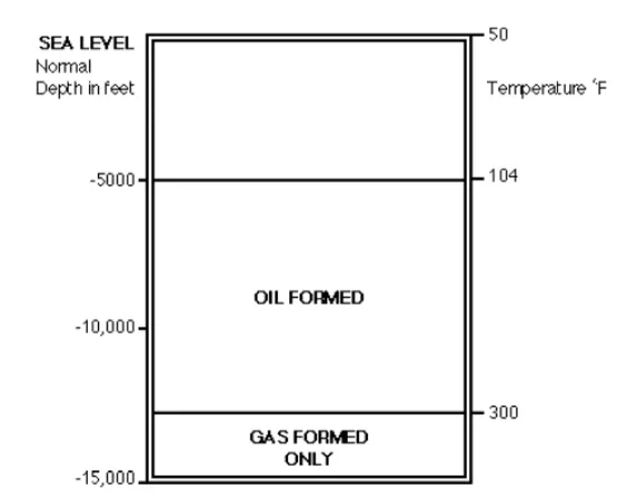
Figure 1 Temperature window for generating hydrocarbons
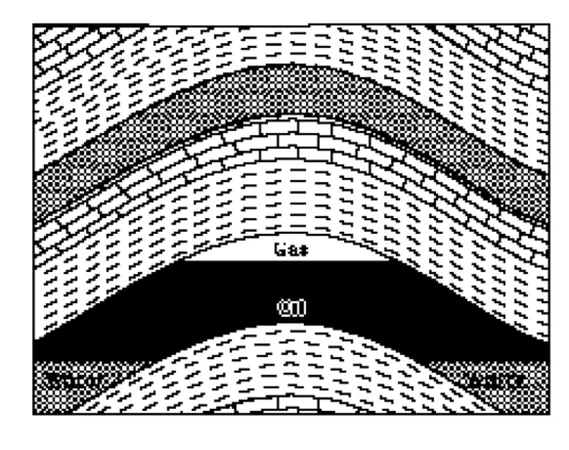
Figure 2 Hydrocarbon reservoir with gas cap, oil zone, and water zone
Figure 3 Hydrocarbon reservoir with no gas cap
During the migration, the reservoir rock needs a trap or seal, so when the fluid migrate it will encounter an impermeable rock. If the fluids continue to migrate when there is no trap or seal, it would go to the surface and dissipate.
Many hydrocarbon reservoirs needs to be mapped before we know the volume and shape of a reservoir. We use petroleum exploration which means process of exploring for oil and gas resources in the earth. How do we explore our huge earth? By some steps, it can be done. Desk study, aerial survey, seismic survey, exploratory drilling, appraisal, development and production are steps to assess a designate field for oil or gas prone.
Desk study
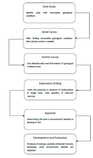
Petroleum Exploration Flowchart
A desk study is the most basic way to define the geological conditions, and the possibility of a petroleum system, below the surface. It can be finished by learning the topographic map, geological map, and literature review of an area. Literature review is the main study research to review the current issues of petroleum exploration and development, planning, and project issues of natural resources and other relevant secondary data information. This secondary data is collected during literature review and during fieldwork interviews by collecting data statistics, documents, or literature about the area. It can be proceeded through a review of academic sources information and discussions.
Aerial survey
After a desk study finds favorable geological features for a petroleum system, an aerial survey is conducted by remote sensing. A remote sensing image analysis can be carried out with geomorphologic information, structure, and to define rock type classification. Seismic survey will be done when aerial survey informations are prospective for a explorers.
Seismic survey
In petroleum survey, conducting seismic survey is important to achieve subsurface imagery of survey area. It is operated by contractors (oil field service company) or the oil company itself. Seismic survey can be conducted whether in land, marine, or transition zone; and the procedure of all types of seismic survey is quite the same, when source used in field acquisition is geophone and marine is hydrophone.
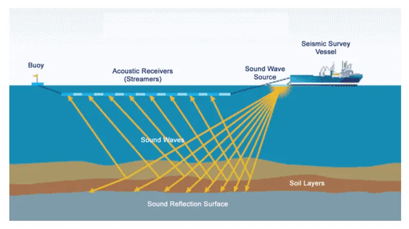
Figure 4 Marine Seismic Acquisition
Figure 5 Land Seismic Acquisition
The survey is started with laying out the line to determine the position of source point and center of geophone group. This work is conducted by the surveyors who also responsible to plan the access route for all survey crew and following works.
In seismic survey, determining field layouts is needed to get expected result. Once the layout is assigned, the rest of survey’s procedure must follow the layout plan. The layouts that must be planned include spread type, common-midpoint method, array concept, and other special methods.
Spread is relative location of source and center of geophones used to record reflected seismic wave. Particular type of spread to reduce the noise and unusable trace recorded by geophone group which lies adjacent with the source. The common spread type used is asymmetrical spread.
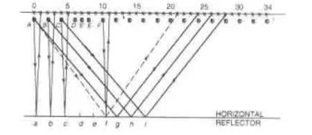
Figure 7 Vertical section illustrating CMP recording The 0 represent source location and x represent geophone group location
Figure 6 Types of spread. The 0 represent source location and x represent geophone group location (source: Sheriff[2]).
Figure 8 Seismic section as result of seismic data processing
Common-Midpoint (CMP) methods is used when each reflecting point is sampled than one. Although some surveys conduct singlefold recording, CMP method is common in seismic survey. Recorded data can be displayed in common-shot gather, common-receiver gather, or common-midpoint gather.
Array is distribution of sources that fired simultaneously.[2] Arrays will provide a way to discriminate waves which arrived from different directions, either vertically or horizontally from source arrays. Determining array concepts will include tapered arrays, areal arrays, and array constraints. Types of arrays used are sometimes determined from preliminary noise analysis.
After planning field layout, determining field parameters is not less important. Some of field parameters are maximum offset, minimum offset, array length, group interval, and number of channel. Other field parameters sometimes are obtained with field testing. To define the near surface, uphole survey is conducted to find the thickness and velocity of low- velocity layer; which will be followed by seismic refraction.
When the acquisition is complete, data processing is conducted to increase signal to noise ratio and obtain imagery of the subsurface. The process include noise attenuation, velocity analysis, deconvolution, migration, stacking, and so on. Once the data have been processed and resulted in form of seismic section, the seismic sequence will be interpreted to find out the underlying structure, stratigraphic sequence, and find the petroleum system.
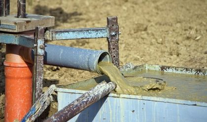
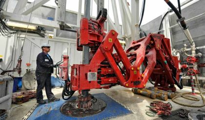
Exploratory Drilling
The data collected from the geologic and geophysical surveys will conclude to a possibility of oil resources location. However, the conclusion is not definite enough before petroleum is now to be existed in the trap, and the quantity is sufficient to make the production activity economical. The only way to provide a definite answers is to drill and test exploratory well(s).
Figure 9 Standard cable tool drilling system

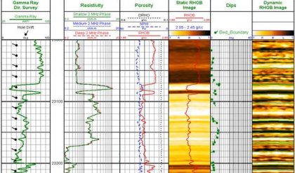
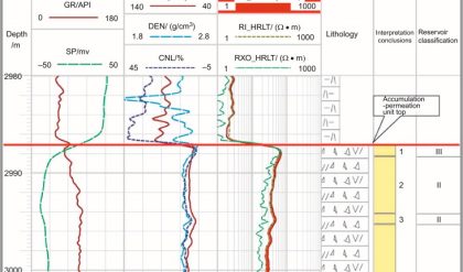
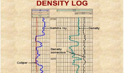
Figure 10 Well log obtained from wireline logging
The exploratory well location is determined by geologists and geophysicists. Samples of the rock cuttings obtained from exploratory drilling are collected and examined to identify the type of formation and the presence of hydrocarbon materials within the rock based on sample’s composition.
Besides rock cutting examination, well logging are also run. Well logging will provide information about rock and fluid properties based on type of logging operated. The tools are placed to the well using electric cable (wireline). There are various type of wireline logging: radioactive log, consists of Gamma Ray, Neutron, and Density; electric log, consists of SP and resistivity; acoustic log; image log; and sampling. Logging will provide information of rock or fluid properties versus depth.
The data provided by one exploratory well may not be sufficient, so additional exploratory drilling is needed to provide better information of the petroleum system. Along with seismic section, well logs will provide data to calculate volume of hydrocarbon stored and conclude whether the production will be economically feasible.

Comments are closed.