Formation process
From planktonic remains to kerogen: the immature stage
Although it is recognized that the original source of carbon and hydrogen was in the materials that made up primordial Earth, it is generally accepted that these two elements had to pass through an organic phase to be combined into the varied complex molecules recognized as hydrocarbons. The organic material that is the source of most hydrocarbons has probably been derived from single-celled planktonic (free-floating) plants, such as diatoms and blue-green algae, and single-celled planktonic animals, such as foraminifera, which live in aquatic environments of marine, brackish, or fresh water. Such simple organisms are known to have been abundant long before the Paleozoic Era, which began some 541 million years ago.
Rapid burial of the remains of the single-celled planktonic plants and animals within fine-grained sediments effectively preserved them. This provided the organic materials, the so-called protopetroleum, for later diagenesis (a series of processes involving biological, chemical, and physical changes) into true petroleum.
The first, or immature, stage of hydrocarbon formation is dominated by biological activity and chemical rearrangement, which convert organic matter to kerogen. This dark-coloured insoluble product of bacterially altered plant and animal detritus is the source of most hydrocarbons generated in the later stages. During the first stage, biogenic methane is the only hydrocarbon generated in commercial quantities. The production of biogenic methane gasis part of the process of decomposition of organic matter carried out by anaerobic microorganisms (those capable of living in the absence of free oxygen).
From kerogen to petroleum: the mature stage
Deeper burial by continuing sedimentation, increasing temperatures, and advancing geologic age result in the mature stage of hydrocarbon formation, during which the full range of petroleum compounds is produced from kerogen and other precursors by thermal degradation and cracking (in which heavy hydrocarbon molecules are broken up into lighter molecules). Depending on the amount and type of organic matter, hydrocarbon generation occurs during the mature stage at depths of about 760 to 4,880 metres (2,500 to 16,000 feet) at temperatures between 65 °C and 150 °C (150 °F and 300 °F). This special environment is called the “oil window.” In areas of higher than normal geothermal gradient (increase in temperature with depth), the oil window exists at shallower depths in younger sediments but is narrower. Maximum hydrocarbon generation occurs from depths of 2,000 to 2,900 metres (6,600 to 9,500 feet). Below 2,900 metres, primarily wet gas, a type of gas containing liquid hydrocarbons known as natural gas liquids, is formed.
Approximately 90 percent of the organic material in sedimentary source rocksis dispersed kerogen. Its composition varies, consisting of a range of residual materials whose basic molecular structure takes the form of stacked sheets of aromatic hydrocarbon rings in which atoms of sulfur, oxygen, and nitrogen also occur. Attached to the ends of the rings are various hydrocarbon compounds, including normal paraffin chains. The mild heating of the kerogen in the oil window of a source rock over long periods of time results in the cracking of the kerogen molecules and the release of the attached paraffin chains. Further heating, perhaps assisted by the catalytic effect of clay minerals in the source rock matrix, may then produce soluble bitumen compounds, followed by the various saturated and unsaturated hydrocarbons, asphaltenes (precipitates formed from oily residues), and others of the thousands of hydrocarbon compounds that make up crude oil mixtures. At the end of the mature stage, below about 4,800 metres (16,000 feet), depending on the geothermal gradient, kerogen becomes condensed in structure and chemically stable. In this environment, crude oil is no longer stable, and the main hydrocarbon product is dry thermal methane gas.
The geologic environment
Origin in source beds
Knowing the maximum temperature reached by a potential source rock during its geologic history helps in estimating the maturity of the organic material contained within it. This information may also indicate whether a region is gas-prone, oil-prone, both, or neither. The techniques employed to assess the maturity of potential source rocks in core samples include measuring the degree of darkening of fossil pollen grains and the colour changes in conodont fossils. In addition, geochemical evaluations can be made of mineralogical changes that were also induced by fluctuating paleotemperatures. In general, there appears to be a progressive evolution of crude oil characteristics from geologically younger, heavier, darker, more aromatic crudes to older, lighter, paler, more paraffinic types. There are, however, many exceptions to this rule, especially in regions with high geothermal gradients. Accumulations of petroleum are usually found in relatively coarse-grained, permeable, and porous sedimentary reservoir rocks laid down, for example, from sand dunes or oxbow lakes; however, these rocks contain little, if any, insoluble organic matter. It is unlikely that the vast quantities of oil and natural gas now present in some reservoir rocks could have been generated from material of which no trace remains. Therefore, the site where commercial amounts of oil and natural gas originated apparently is not always identical to the location at which they are ultimately discovered.
Oil and natural gas is believed to have been generated in significant volumes only in fine-grained sedimentary rocks (usually clays, shales, or clastic carbonates) by geothermal action on kerogen, leaving an insoluble organic residue in the source rock. The release of oil from the solid particles of kerogen and its movement in the narrow pores and capillaries of the source rock is termed primary migration. Accumulating sediments can provide energy to the migration system. Primary migration may be initiated during compaction as a result of the pressure of overlying sediments. Continued burial causes clay to become dehydrated by the removal of water molecules that were loosely combined with the clay minerals. With increasing temperature, the newly generated hydrocarbons may become sufficiently mobile to leave the source beds in solution, suspension, or emulsion with the water being expelled from the compacting molecular lattices of the clay minerals. The hydrocarbon molecules would compose only a very small part—a few hundred parts per million—of the migrating fluids.
Migration through carrier beds
The hydrocarbons expelled from a source bed next move through the wider pores of carrier beds (e.g., sandstones or carbonates) that are coarser-grained and more permeable. This movement is termed secondary migration and may be the result of rocks folding or raising from changes associated with plate tectonics. The distinction between primary and secondary migration is based on pore size and rock type. In some cases, oil may migrate through such permeable carrier beds until it is trapped by a nonporous barrier and forms an oil accumulation. Although the definition of “reservoir” implies that the oil and natural gas deposit is covered by more nonporous and nonpermeable rock, in certain situations the oil and natural gas may continue its migration until it becomes a seep on the surface, where it will be broken down chemically by oxidation and bacterial action. Since nearly all pores in subsurface sedimentary formations are water-saturated, the migration of oil takes place in an aqueous environment. Secondary migration may result from active water movement or can occur independently, either by displacement or by diffusion. Because the specific gravity of the water in the sedimentary formation is considerably higher than that of oil and natural gas, both oil and natural gas will float to the surface of the water in the course of geologic time and accumulate in the highest portion of a trap. The collection under the trap is an accumulation of gas with oil and then formation water at the bottom. If salt is present in an area of weakness or instability near the trap, it can use the pressure difference between the rock and the fluids to intrude into the trap, forming a dome. The salt dome can be used as a subsurface storage vault for hazardous materials or natural gas.
Accumulation in reservoir beds
The porosity (volume of pore spaces) and permeability (capacity for transmitting fluids) of carrier and reservoir beds are important factors in the migration and accumulation of oil. Most conventional petroleum accumulations have been found in clastic reservoirs (sandstones and siltstones). Next in number are the carbonate reservoirs (limestones and dolomites). Accumulations of certain types of unconventional petroleum (that is, petroleum obtained through methods other than traditional wells) occur in shales and igneous and metamorphic rocks because of porosity resulting from fracturing. Porosities in reservoir rocks usually range from about 5 to 30 percent, but all available pore space is not occupied by petroleum. A certain amount of residual formation water cannot be displaced and is always present. Reservoir rocks may be divided into two main types: (1) those in which the porosity and permeability is primary, or inherent, and (2) those in which they are secondary, or induced. Primary porosity and permeability are dependent on the size, shape, and grading and packing of the sediment grains and also on the manner of their initial consolidation. Secondary porosity and permeability result from postdepositional factors, such as solution, recrystallization, fracturing, weathering during temporary exposure at Earth’ssurface, and further cementation. These secondary factors may either enhanceor diminish the initial porosity and permeability.
Traps
After secondary migration in carrier beds, oil and natural gas finally collect in a trap. The fundamental characteristic of a trap is an upward convex form of porous and permeable reservoir rock that is sealed above by a denser, relatively impermeable cap rock (e.g., shale or evaporites). The trap may be of any shape, the critical factor being that it is a closed inverted container. A rare exception is hydrodynamic trapping, in which high water saturation of low-permeability sediments reduces hydrocarbon permeability to near zero, resulting in a water block and an accumulation of petroleum down the structural dip of a sedimentary bed below the water in the sedimentary formation.
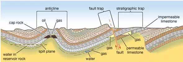
Principal types of petroleum traps.
Structural traps
Traps can be formed in many ways. Those formed by tectonic events, such as folding or faulting of rock units, are called structural traps. The most common structural traps are anticlines, upfolds of strata that appear as inverted V-shaped regions on the horizontal planes of geologic maps. About 80 percent of the world’s petroleum has been found in anticlinal traps. Most anticlines were produced by lateral pressure, but some have resulted from the draping and subsequent compaction of accumulating sediments over topographic highs. The closure of an anticline is the vertical distance between its highest point and the spill plane, the level at which the petroleum can escape if the trap is filled beyond capacity. Some traps are filled with petroleum to their spill plane, but others contain considerably smaller amounts than they can accommodate on the basis of their size.
Another kind of structural trap is the fault trap. Here, rock fracture results in a relative displacement of strata that form a barrier to petroleum migration. A barrier can occur when an impermeable bed is brought into contact with a carrier bed. Sometimes the faults themselves provide a seal against “updip” migration when they contain impervious clay gouge material between their walls. Faults and folds often combine to produce traps, each providing a part of the container for the enclosed petroleum. Faults can, however, allow the escape of petroleum from a former trap if they breach the cap rock seal. Other structural traps are associated with salt domes. Such traps are formed by the upward movement of salt masses from deeply buried evaporite beds, and they occur along the folded or faulted flanks of the salt plug or on top of the plug in the overlying folded or draped sediments.
Stratigraphic traps
A second major class of petroleum traps is the stratigraphic trap. It is related to sediment deposition or erosion and is bounded on one or more sides by zones of low permeability. Because tectonics ultimately control deposition and erosion, however, few stratigraphic traps are completely without structural influence. The geologic history of most sedimentary basins contains the prerequisites for the formation of stratigraphic traps. Typical examples are fossil carbonate reefs, marine sandstone bars, and deltaic distributary channel sandstones. When buried, each of these features provides a potential reservoir, which is often surrounded by finer-grained sediments that may act as source or cap rocks. Sediments eroded from a landmass and deposited in an adjacent sea change from coarse- to fine-grained with increasing depth of water and distance from shore. Permeable sediments thus grade into impermeable sediments, forming a permeability barrier that eventually could trap migrating petroleum. There are many other types of stratigraphic traps. Some are associated with the many transgressions (advances) and regressions (retreats) of the sea that have occurred over geologic time and the resulting deposits of differing porosities. Others are caused by processes that increase secondary porosity, such as the dolomitization of limestones or the weathering of strata once located at Earth’s surface.
Resources And Reserves
Reservoirs formed by traps or seeps contain hydrocarbons that are further defined as either resources or reserves. Resources are the total amount of all possible hydrocarbons estimated from formations before wells are drilled. In contrast, reserves are subsets of resources; the sizes of reserves are determined by how economically or technologically feasible they are to extract petroleum from and use under current technological and economic conditions. Reserves are classified into various categories based on the amount that is likely to be extracted. Proven reserves have the highest certainty of successful extraction for commercial use (more than 90 percent), whereas successful extraction regarding probable and possible reserves for commercial use are estimated at 50 percent and between 10 and 50 percent respectively.
The broader category of resources includes both conventional and unconventional petroleum plays (or accumulations) as identified by analogs—that is, fields or reservoirs where there are few or no wells drilled but which are similar geologically to producing fields. For resources where some exploration or discovery activity has taken place, estimates of the size and number of undiscovered hydrocarbon accumulations are determined by technical experts and geoscientists as well as from measurements derived from geologic framework modeling and visualizations.
Unconventional oil
Within the vast unconventional resources category, there are several different types of hydrocarbons, including very heavy oils, oil sands, oil shales, and tight oils. By the early 21st century, technological advances had created opportunities to convert what were once undeveloped resource plays into economic reserves. Very heavy crudes have become economical. Those having less than 15° API can be extracted by working with natural reservoir temperatures and pressures, provided that the temperatures and pressures are high enough. Such conditions occur in Venezuela’s Orinoco basin, for example. On the other hand, other very heavy crudes, such as certain Canadian crude oils, require the injection of steam from horizontal wells that also allow for gravity drainage and recovery. Tar sands differ from very heavy crude oil in that bitumen adheres to sand particles with water. In order to convert this resource into a reserve, surface mining or subsurface steam injection into the reservoir must take place first. Later the extracted material is processed at an extraction plant capable of separating the oil from the sand, fines (very small particles), and water slurry.
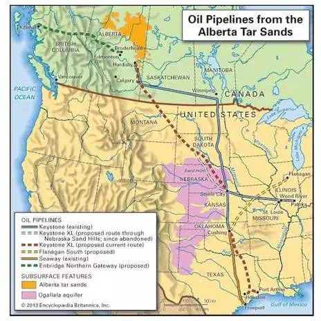
Alberta tar sandsThe location of the Alberta tar sands region and its associated oil pipelines.
Oil shales make up an often misunderstood category of unconventional oils in that they are often confused with coal. Oil shale is an inorganic, nonporous rock containing some organic kerogen. While oil shales are similar to the source rock producing petroleum, they are different in that they contain up to 70 percent kerogen. In contrast, source rock tight oils contain only about 1 percent kerogen. Another key difference between oil shales and the tight oil produced from source rock is that oil shale is not exposed to sufficiently high temperatures to convert the kerogen to oil. In this sense, oil shales are hybrids of source rock oil and coal. Some oil shales can be burned as a solid. However, they are sooty and possess an extremely high volatile matter content when burned. Thus, oil shales are not used as solid fuels, but, after they are strip-mined and distilled, they are used as liquid fuels. Compared with other unconventional oils, oil shale cannot be extracted practically through hydraulic fracturing or thermal methods at present. Shale oil is a kerogen-rich oil produced from oil shale rock. Shale oil, which is distinguished physically from heavy oil and tar sands, is an emerging petroleum source, and its potential was highlighted by the impressive production from the Bakken fields of North Dakota by the 2010s, which greatly boosted the state’s petroleum output. (By 2015 North Dakota’s daily petroleum production was approximately 1.2 million barrels, roughly 80 percent the amount produced per day by the country of Qatar, which is a member of Organization of the Petroleum Exporting Countries [OPEC].)
Tight oil is often light-gravity oil which is trapped in formations characterized by very low porosity and permeability. Tight oil production requires technologically complex drilling and completion methods, such as hydraulic fracturing (fracking) and other processes. (Completion is the practice of preparing the well and the equipment to extract petroleum.) The construction of horizontal wells with multi-fracturing completions is one of the most effective methods for recovering tight oil.
Formations containing light tight oil are dominated by siltstone containing quartz and other minerals such as dolomite and calcite. Mudstone may also be present. Since most formations look like shale oil on data logs (geologic reports), they are often referenced as shale. Higher-productivity tight oil appears to be linked to greater total organic carbon (TOC; the TOC fraction is the relative weight of organic carbon to kerogen in the sample) and greater shale thickness. Taken together, these factors may combine to create greater pore-pressure-related fracturing and more efficient extraction. For the most productive zones in the Bakken, TOC is estimated at greater than 40 percent, and thus it is considered to be a valuable source of hydrocarbons.
Other known commercial tight oil plays are located in Canada and Argentina. For example, Argentina’s Vaca Muerta formation was expected to produce 350,000 barrels per well when fully exploited, but by the early 21st century only a few dozen wells had been drilled, which resulted in production of only a few hundred barrels per day. In addition, Russia’s Bazhenov formation in west Siberia has 365 billion barrels of recoverable reserves, which is potentially greater than either Venezuela’s or Saudi Arabia’s proved conventional reserves.
Considering the commercial status of all unconventional petroleum resource plays, the most mature reside within the conterminous United States, where unconventional petroleum in the liquid, solid, and gaseous phases is efficiently extracted. For tight oil, further technological breakthroughs are expected to unlock the resource potential in a manner similar to how unconventional gas has been developed in the U.S.
Unconventional natural gas
Perhaps the most-promising advances for petroleum focus on unconventional natural gas. (Natural gas is a hydrocarbon typically found dissolved in oil or present as a cap for the oil in a petroleum deposit.) Six unconventional gas types—tight gas, deep gas, shale gas, coalbed methane, geopressurized zones, and Arctic and subsea hydrates—form the worldwide unconventional resource base. The scale of difference between conventional and unconventional reserves recoveries are commonly 30 percent to 1 percent, using tight gas as an example. In addition, the volume of the resource base is orders of magnitude higher; for example, 40 percent of all technically recoverable natural gas resources is attributable to shale gas. This total does not include tight gas, coalbed methane, or gas hydrates, nor does it include those shale gas resources that are believed to exist in unproven reserves in Russia and the Middle East. (For a complete description and analysis of unconventional natural

Comments are closed.